Month: June 2022
-
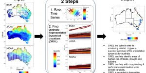
Discovering optimally representative dynamical locations (ORDL) in big multivariate spatiotemporal data: a case study of precipitation in Australia from space to ground sensors
New paper led by Ben Hines points to dynamics and locations of extreme on precipitation events in the Australian continent, using data from BoM’s rain gauge network and multiplatform JAXA-NOAA remote sensing. Read article here. -
Forecasting landslides from space
A new data-driven tool uses satellites to accurately predict devastating natural disasters before they occur – locating potential land failures to protect at-risk communities. Read the story on Pursuit.safe-risccs.science.unimelb.edu.au/2022/06/09/forecasting-landslides-from-space

